
LOADING


Eastway Gardens under construction
Eastway Gardens has been the site of countless construction projects in the past, all of them resulting in significant changes to the landscape, and many leading to the expropriation of area properties. The Eastway Gardens area continues to endure a whirlwind of activity as major construction projects and residential developments unfold. New housing units will attract renters and homebuyers to the area who want to be close to downtown with quick acccess to public transportation.
If the ventures about to take place were prioritized, then potential construction of some 7,000 or more residential units in the area would have to rank high due to its sheer magnitude. Many of these projects were subject to delays and cancellations over the years but are now on track for construction. The Public Lands for Homes Plan itself could add nearly 5,000 residential units to the area.
Also, Eastway Gardens is likely to be significantly affected if the proposed Alto High-Speed Rail megaproject goes ahead. Construction would begin simultaneously at the Ottawa and Montreal ends of the tracks in 2029. Highly publicized possible sites for the Alto train station include the Via Rail terminal/O-Train LRT Line 1 station on Tremblay Road or the old Union Station downtown. A third possible but less talked about location for the Alto station is the large parcel of vacant federal land at the intersection of Tremblay Rd. and St. Laurent Blvd.
Also, Eastway Gardens is likely to be significantly affected if the proposed Alto High-Speed Rail megaproject goes ahead. Construction would begin simultaneously at the Ottawa and Montreal ends of the tracks in 2029. Highly publicized possible sites for the Alto train station include the Via Rail terminal/O-Train LRT Line 1 station on Tremblay Road or the old Union Station downtown. A third possible but less talked about location for the Alto station is the large parcel of vacant federal land at the intersection of Tremblay Rd. and St. Laurent Blvd.
> Major past, present, and future construction projects include:
- 1960 - Avenues A through D removed to accommodate the Alta Vista Drive-Queensway interchange, built as part of the King's Highway (Read more at bottom of the "History of Eastway Gardens" page);
- 1960 - Avenue M replaced by Belfast Road;
- 1966 - Via Rail tracks relocated to Eastway Gardens;
- 1967 - Newly relocated Via Rail train station necessitates removal of Avenues E through H;
- 2013 - Construction begins on LRT Line 1, the Confederation Line (Read more on the "LRT O-Train Line 1" page);
- 2016 - LRT Stage 1 Belfast Maintenance and Storage Facility opens;
- 2017 - Belfast Maintenance and Storage Facility is expanded (Stage 2);
- Mid-2000s - Built in three phases, the Ottawa Train Yards, a 110-acre open-air shopping centre near Eastway Gardens, features over 750,000 square feet of retail space;
- 2017 (approx.) - Highway 417 Expansion East;
- 2026 - Projected construction of an estimated 7,320 residential units in the area within the next few years. (See maps and articles below)
- 2029 - Alto high-speed rail construction between Ottawa and Montreal projected to start in 2029. If approved, the rail lines and station are likely to have a huge impact on the Eastway Gardens residential neighbourhood. Details are evolving at this time and open house consultations are completed. More information is forthcoming. (Read more on the "Alto High-Speed Rail" page).
Potential residential developments
(Refer to maps below.) Due to its proximity to high quality transit facilities, the Eastway Gardens area is designated as a Transit-Oriented Development (TOD) community. A TOD creates dense, walkable, and mixed-use spaces near transit facilities that support vibrant communities. TOD projects include a mix of commercial, office, and entertainment land uses with a focus on residential density. The two maps below illustrate just how many residential units could potentially be added to the area in the coming years.
Locations of current and future commercial residential developments
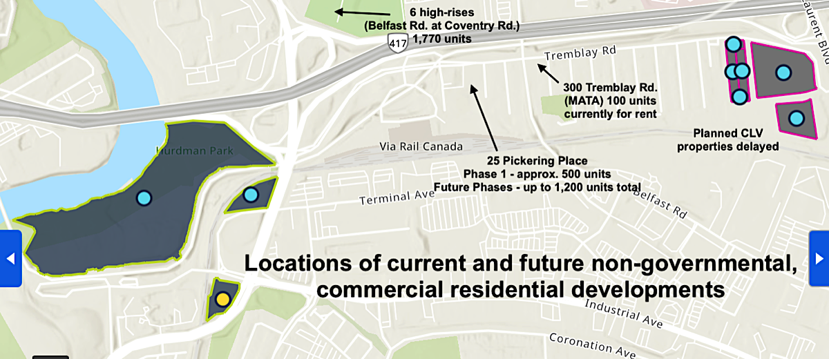
The above map indicates locations of current and future non-governmental, commercial, and residential developments. The map shows that eventually there could be as many as 2,520 units altogether.
A recent addition to Eastway Gardens is a multi-use six-storey building with 100 units and a commercial space built on the site of the former White Horse Restaurant. In January 2026, MATA at 300 Tremblay Road began advertising rental suites and a ground-floor commercial space.
In March 2026, construction began on Phase 1 of a major mixed-use, five-tower project by Colonnade Bridge Port at 25 Pickering Place (also known as 1330 Avenue K). Located near the Via Rail station, Phase 1 plans include two high-rise towers of 14 and 28 storeys, providing approximately 483 rental suites along with ground-floor commercial space. Eventually, six towers will be built. > Read 25 Pickering Presentation and Q&A — February 10, 2026
Construction of other developments planned for the area are pending. Read more about area developments by clicking on the link beneath the photo.
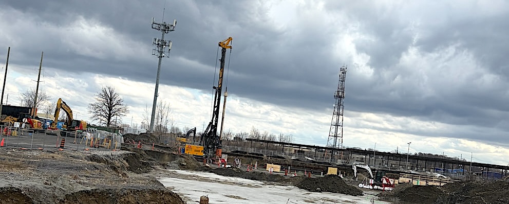
Phase 1 of a major mixed-use project by Colonnade Bridge Port at 25 Pickering Place (also known as 1330 Avenue K). Construction began in March 2026 after a lengthy delay.
Articles - Commercial residential properties
Click on the teal coloured headlines below
Tap on the teal coloured headlines below
-
25 Pickering Presentation and Q&A
Marty Carr, Councillor for Ward 18, Alta Vista, held a well-attended virtual question and answer meeting for residents with representatives from Colonnade Bridgeport regarding pending construction of two high rise towers at "25 Pickering Place".
From the Office of Councillor Marty Carr,
February 3, 2026 -
Colonnade Bridgeport Phase One Details - February, 2026
- 700 Bannermount Avenue will be 28 storeys;
- 720 Bannermount Avenue will be 14 storeys;
- Eventually there will be six buildings on the site.
The ground floors will offer 2,770 square feet of retail space. It's anticipated that personal service businesses, including yoga studios and coffee shops, would occupy the ground floors, complementing and serving the surrounding neighbourhood.
The development will include 255 underground parking stalls,
Colonnade Bridgeport has dedicated 2300 square meters in their plan of subdivision for a park, which will eventually be planned and designed by the City.
TIMELINES- Siteworks Commencement: Week of February 3, 2026
- Excavation and Shoring Start: Week of February 17, 2026
- Construction reaches grade: Estimated October 2026
- First Occupancy: Estimated December 2027
- Construction Completion: Estimated January 2029
-
25 Pickering Place Site Plan (Phase 1)
Site Plan - 14 & 28 story residential high rises (PDF)
Undated
Webcast.Ottawa -
25 Pickering Place Bannermount Avenue Block
Schematic Landscape Plan / Tree Inventory Report
April 1, 2024
Webcast.Ottawa -
25 Pickering Place Mixed-Use High-Rise Development
A Site Plan Control application has been submitted to the City of Ottawa for the redevelopment of 25 Pickering Place. The proposal involves the construction of two mixed-use high-rise apartment buildings, one 28 stories and the other 14 stories high. The buildings will contain approximately 483 residential units and commercial spaces on the ground floor, with underground parking accessed from Bannermount Avenue.
September 20, 2024
Canada Commons -
300 Tremblay Road
Undated
Pomerleau -
MATA (300 Tremblay Road)
January, 2026
MATA -
Ottawa planning committee approves six-tower development near St. Laurent Station
August 26, 2025
By Special to Ontario Construction News
Ontario Construction News
The City of Ottawa’s planning and housing committee has approved amendments to official plan and zoning rules that would allow a six-tower residential development to be built near St. Laurent Station. -
Planning and Housing Committee approves 6-tower development near St. Laurent mall
August 20, 2025
By Ted Raymond
CTV Ottawa News
The City of Ottawa’s planning and housing committee has approved a plan to build six towers between 21 and 35 storeys on Coventry Road near the St. Laurent Shopping Centre and transit station.
The plan would lead to the creation of 1,770 housing units in a lot situated between Coventry Road and Highway 417 on the west side of Belfast Road. -
Six-tower housing project on Coventry Road OK'd by Ottawa committee
The site is north of Highway 417 and west of the St. Laurent Shopping Centre and is currently occupied by Enbridge Gas.
August 20, 2025
By Aedan Helmer
Ottawa Citizen
The City of Ottawa’s planning and housing committee approved the proposed construction of a six-tower highrise complex that would create about 1,770 housing units along Coventry Road near the St. Laurent Shopping Centre and transit station. -
1399 Avenue U
Construction of a residential development at 1399 Avenue U, proposed by CLv Group Developments, was postponed indefinitely due to the cancellation of a planned Canada Lands Corporation (CLC) development at 599 and 470 Tremblay Road (intersection of Tremblay Road and St. Laurent Boulevard). Originally, construction access for the 1399 Avenue U project was to be provided via the sites of 599 and 470 Tremblay Rd.
Clv Group Developments
-
1399 Avenue U Details
1399 Avenue U was to be located south of Tremblay Road, abutting the stub ends of Avenues P, S, T and U. The proposed development included two residential buildings, with a potential third building that was to proceed through a separate site plan control process in the future. The two buildings were to consist of studios and one, two, and three-bedroom units with private balconies as well as communal amenity space located at grade and on the rooftop. A total of 136 vehicular-parking spaces for residents and visitors were proposed underground and on the surface at the rear of the site – abutting the rail-lines.
Clv Group Developments
Locations of properties in the Canada Public Land Bank Inventory
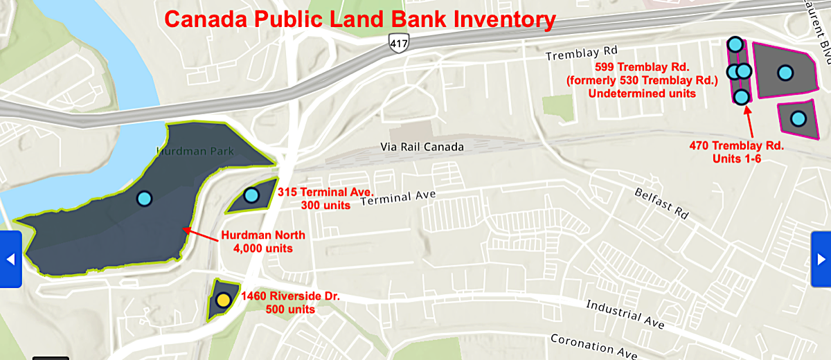
•Blue dots = properties "Open for feedback" | •Yellow dots = "Submissions under review"
> Click here for a larger view of this map
The above map indicates locations of POSSIBLE future residential developments in the area currently held in the Federal Government's Canada Public Land Bank Inventory. This map shows that, in the wider Eastway Gardens area, there could eventually be as many as 4,800 units in the Inventory.
UPDATE ON 1460 RIVERSIDE DRIVE
April 2, 2026, from Alta Vista Councillor Marty Carr — The National Capital Commission has entered into a lease agreement with Ottawa Community Housing and non-profit real estate developer Nesting Ground for the vacant lot at 1460 Riverside Dr., clearing one entry off the list of properties the federal government has earmarked for affordable housing.
The lease agreement for the Riverside lot was approved for a 99-year period earlier this month. A government registry lists the Ottawa Community Housing Corporation and Nesting Ground as co-tenants on the property. The proposed project will include at least 220 residential housing units, of which at least 30 per cent will be offered at below-market rates (less than 80 per cent of Ottawa’s median market rent), according to the registry.
Please note that this is a federal process at this point. Applicants will need to file through the City’s development process and it is at this time that more details will be done as to number of units, level of affordability, and building design.
> (Mar 30, 2026) NCC reaches lease deal for first Ottawa property on affordable housing land bank
Lease agreement for the vacant lot at 1460 Riverside Drive is the first for an Ottawa-Gatineau property listed on the Canada Public Land Bank.
By Ben Andrews
Ottawa Citizen
In 2009, Public Works and Government Services Canada (PWGSC) acquired a 10.7 hectare (26.4 acre) parcel of land at 599 Tremblay Road (formerly known as 530 Tremblay Road). At the time, the federal government planned to partner with a private-sector developer to build a mixed-use complex.
Of this land, approximately 3.2 hectares (7.9 acres) located at the intersection of Tremblay Rd. and St. Laurent Blvd., was intended for a 1.6-million-square-foot federal office complex adjacent to the St, Laurent O-Train station. The development was envisioned as a massive mixed-use, net-zero carbon campus to house 8,000 federal employees and potentially replace older buildings. The project was scrapped in early 2023, however, reflecting a wider trend in the federal government to downsize its office footprint.
On this 26.4 acre property, six units at 470 Tremblay Rd. have recently been added to the Canada Lands inventory.
Meanwhile, a site plan application submitted by CLV Group in 2019 for two 5-6 storey buildings at 1399 Avenue U, totalling 129 units, has been delayed indefinitely, awaiting the federal government’s decisions on 599/530 Tremblay Rd.
Articles - Canada Land Bank properties
Click on the teal coloured headlines below
Tap on the teal coloured headlines below
-
NCC reaches lease deal for first Ottawa property on affordable housing land bank
Lease agreement for the vacant lot at 1460 Riverside Drive is the first for an Ottawa-Gatineau property listed on the Canada Public Land Bank.
By Ben Andrews
Mar 30, 2026
Ottawa Citizen -
How Canada Wins: Housing in former federal office buildings can revitalize Ottawa neighbourhoods
By Matteo Cimellaro
Published Mar 28, 2025
Ottawa Citizen -
Minister Sudds highlights 9 federal properties in the National Capital Region available for housing development
Employment and Social Development Canada
News release
October 16, 2024
Government of Canada -
7 more federal properties available for housing in Ottawa, including 3 near busy transit station
By Josh Pringle
Published: Oct 08, 2024
CTV News Ottawa -
Federal government to use 22 properties in Ottawa for housing
The government launched the Canada Public Land Bank, a new tool listing federal properties identified as able to support housing.
By Catherine Morrison
Published: Aug 26, 2024
Ottawa Citizen -
470 Tremblay Road (Sites 1 - 6)
These properties, listed in the Canada Public Land Bank Inventory, are located on vacant land at the intersection of Tremblay Rd. and St. Laurent Blvd. that was the original site of a cancelled federal government office complex.
Public lands interactive mapping tool -
599 (formerly 530) Tremblay Road
This property, listed in the Canada Public Land Bank Inventory, is located on vacant land at the intersection of Tremblay Rd. and St. Laurent Blvd. that was the original site of a cancelled federal government office complex.
Public lands interactive mapping tool
Canada Public Land Bank Inventory


Excerpt From:
“Canada Public Land Bank - Public lands for homes”
Undated
Government of Canada
"There are currently 88 properties listed, representing the potential for construction of thousands of housing units on a total of 463 hectares of land across Canada.
Properties were selected because of their suitability for housing development. We are continuing to review federal surplus and underutilized properties, as well as actively working with partners to identify more properties for development. If you are aware of a federal property that is currently not in use and has housing potential, please email us the location and a brief proposal…."
Canada Public Land Bank interactive mapping tool
TAP ON THE MAP BELOW TO ACCESS INTERACTIVE MAP
Tip: Search for Ottawa and scroll down over dots on the right column. Tap on each dot for details.
Tip: Search for Ottawa and scroll down over dots on the right column. Tap on each dot for details.
Click on the map below to access the interactive map
Tip: Search for Ottawa and scroll down over dots on the right column. Click on each dot for details.
Tip: Search for Ottawa and scroll down over dots on the right column. Click on each dot for details.

•Blue dots = properties "Open for feedback" | •Yellow dots = "Submissions under review" | •Green dots = properties "Accepting submissions"
List of federal properties (* indicates recently added)
* •315 Terminal Avenue - 300 units (Open for feedback)
* •470 Tremblay Road Sites 1 - 6) (Open for feedback)
* •599 Tremblay Road - (Open for feedback)
As of February 2026, there are two major federal and municipal projects active in the Hurdman O-Train Station area:
1. •Hurdman North Development (Public Lands for Homes) - 4,000 units( Open for feedback)
- Located just south of Highway 417 and west of Riverside Drive, this parcel was added to the Canada Public Land Bank to accelerate housing.
- * Capacity: Identified as having potential for 4,000 housing units.
- * Status: Part of the "Public Lands for Homes Plan" aimed at unlocking underused federal land for transit-oriented development.
- Located near the 417 interchange and Hurdman Station, this 0.89-hectare site is being developed through the Federal Lands Initiative.
- Project: A minimum of 220 affordable housing units (potential for up to 500).
- Proponents: Nesting Ground and Ottawa Community Housing Corporation were identified as co-tenants for the 99-year leasehold.
> Read more on the "LRT O-Train Line 1" page

Eastway Gardens is a transit-oriented neighbourhood
> EXPLAINED: The Canada Lands Company (CLC), the Canada Public Land Bank (CPLB), and the Public Lands for Homes Plan
The Canada Lands Company (CLC) is a self-financing federal Crown corporation that develops and manages real estate, whereas the Canada Public Land Bank (CPLB) is an online inventory (database) of federal properties identified for housing development. CLC acts as the operator, developing land from the bank to create housing, while the bank acts as the repository.
KEY DIFFERENCES
Definition: The Canada Public Land Bank is a tool/database showcasing federal land available for housing. The Canada Lands Company is the Crown corporation tasked with developing these sites.
Function: The Land Bank lists properties (over 90 as of Jan 2025) for public viewing, while the CLC manages the sale, leasing, and redevelopment of these lands.
Role in Housing: The CPLB identifies potential, while the CLC (in partnership with CMHC) launches calls for proposals to actually build homes.
Relationship: The CLC helps manage the land listed within the Public Land Bank.
Both are part of the Public Lands for Homes Plan, aimed at accelerating the construction of housing on surplus federal properties.
> Read more on the "LRT O-Train Line 1" page
Banner Photo Credits:
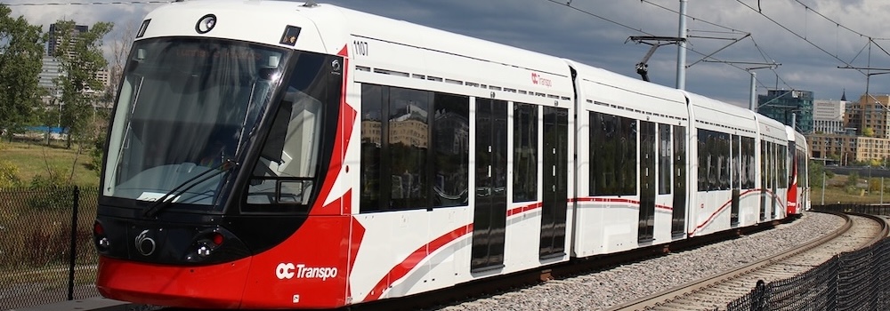
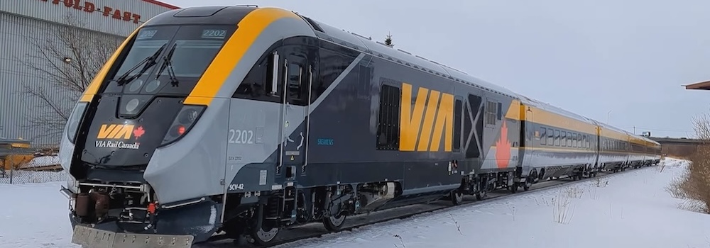
• Via Rail train - Keira Clarke, CC BY 4.0, via Wikimedia Commons
• OC Transpo Train LRV - By *Youngjin - Own work, CC BY-SA 3.0
• Via Rail train - Keira Clarke, CC BY 4.0
.jpg)
• OC Transpo Train LRV - By *Youngjin - Own work, CC BY-SA 3.0
To Top